Description
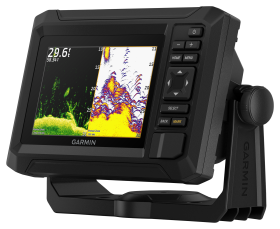
Get a sharper view from your connected helm with the Garmin® GPSMAP® 743xsv 7″ Chartplotter with Sonar and Garmin Navionics+ Mapping. Its higher-resolution 7″ display has 60% more pixels than previous-generation chartplotters. With its compact footprint, vivid sonar color palette, and nearly double the processing power of previous-generation GPSMAP devices, it seamlessly integrates into your Garmin marine system. The GPSMAP 743xsv also features built-in Ultra High-Definition SideVü™ and ClearVü™ scanning sonars and support for 1kW CHIRP traditional sonar as well as fully networkable radar and live sonar devices (transducers not included). Preloaded Garmin Navionics+™ coastal charts and inland mapping feature Auto Guidance+™ technology to help you get where you need to go. Plus, there’s support for optional Garmin Navionics Vision+™ optional premium map content. Easily build your marine system, from compatible sonar and autopilots to compatible radar, cameras, and multimedia, by using HTML 5.0, NMEA 2000®, and NMEA 0183 networking, J1939 for engines, and the Garmin Marine Network. Or pair your plotter with your other compatible Garmin devices such as quatix® marine smartwatches, wind transducers, wireless remote controls, and more (extra devices not included). The Garmin GPSMAP redefines possibilities on the water. Higher-resolution 7″ display; 60% more pixels than previous-generation chartplotters; Compact footprint; Vivid sonar color palette; Nearly twice the processing power of previous-generation GPSMAP devices; Built-in Ultra High-Definition SideVü™ and ClearVü™ scanning sonars; Support for 1kW CHIRP traditional sonar as well as fully networkable radar and live sonar devices (transducers not included); Support for optional Garmin Navionics Vision+™ optional premium map content; HTML 5.0, NMEA 2000®, and NMEA 0183 networking; J1939 connectivity for engine data; Garmin Marine Network connectivity;